Norris Reservation (Norwell, MA)


IMG_6938

Date Of Visit: September 15, 2019

Location: Norris Reservation, 10 Dover St, Norwell, MA

Hours: Open daily, sunrise to sunset

Cost: Free

Trail Size/Difficulty: 2.3 miles (129 acres)/easy

Parking: There is room in the parking lot for about a dozen cars and several universally accessible spaces.  Since the parking lot fills up quickly, especially during the warmer seasons, parking is allowed on the side of the road in front of and next to the lot.  You may find parking in the parking lot across the street (although I never told you that)

Universally Accessible: Yes (there are some boardwalks and even trails, although some of the trails may be challenging as they are rocky and there are some gentle inclines)

Dog Friendly: Yes

Highlights: boat house, pond, boardwalks, fishing,scenic views, wildlife

Summary: Once the site of a mill (an unmarked stone along the trail appears to indicate where the mill may have been located), Norris Reservation has pretty views of the North River.  An old boat house, which doesn’t seem to be in use any longer, offers scenic views and a nice place to rest during hot summer days.

Website: Norris Reservation

Trail Map: Norris Reservation Trail Map

Named after Eleanor Norris and her husband Albert (who she gifted the land in honor in the wake of his passing in 1970), Norris Reservation was once part of the thriving shipbuilding industry.  While the ship building companies have long since left, the reservation and some of the buildings still remain.

One of the most prominent reminders of the shipping industry, mills and boating that took place at the reservation are the boathouse (aka “boat hut”) near the end of the trail and the mill stone placed at the beginning of the trail.


From the deck of the boathouse, there are some great views.


The trails at Norris Reservation are easy.  A boardwalk passes over wetlands that encircle Gordon’s Pond.


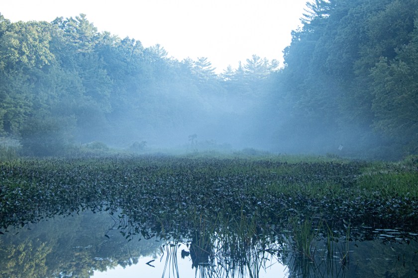
Since it had rained earlier that morning and, due to the warming temperature, there was a slight mist at the reservation.


There was also some very pretty light and shadows visible at the reservation as the sun began to shine through the cloud cover.  While I was driving to the reservation, I had noticed the golden colors, despite the fact it was a bit past the actual “golden hour.”  Luckily, the colors and rays of light were still present when I arrived.


Near the mid-point of the trail, where it curves, there is a nice view of the North River.

IMG_7065

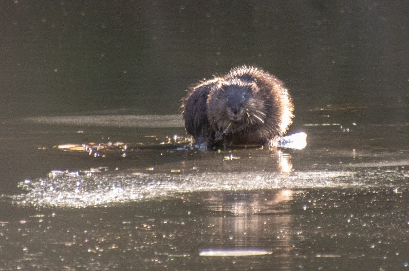
While I didn’t observe some of the animals known to inhabit the reservation (such as beavers, water snakes, turtles), I did see a duck, frog and this cute chipmunk who seemed to be looking out for predators.


There was also some natural work of art at the reservation.  These spider webs were visible on the boardwalk.


Fishing is also allowed at the reservation.  One of the visitors there told me trout is a common type of fish there.

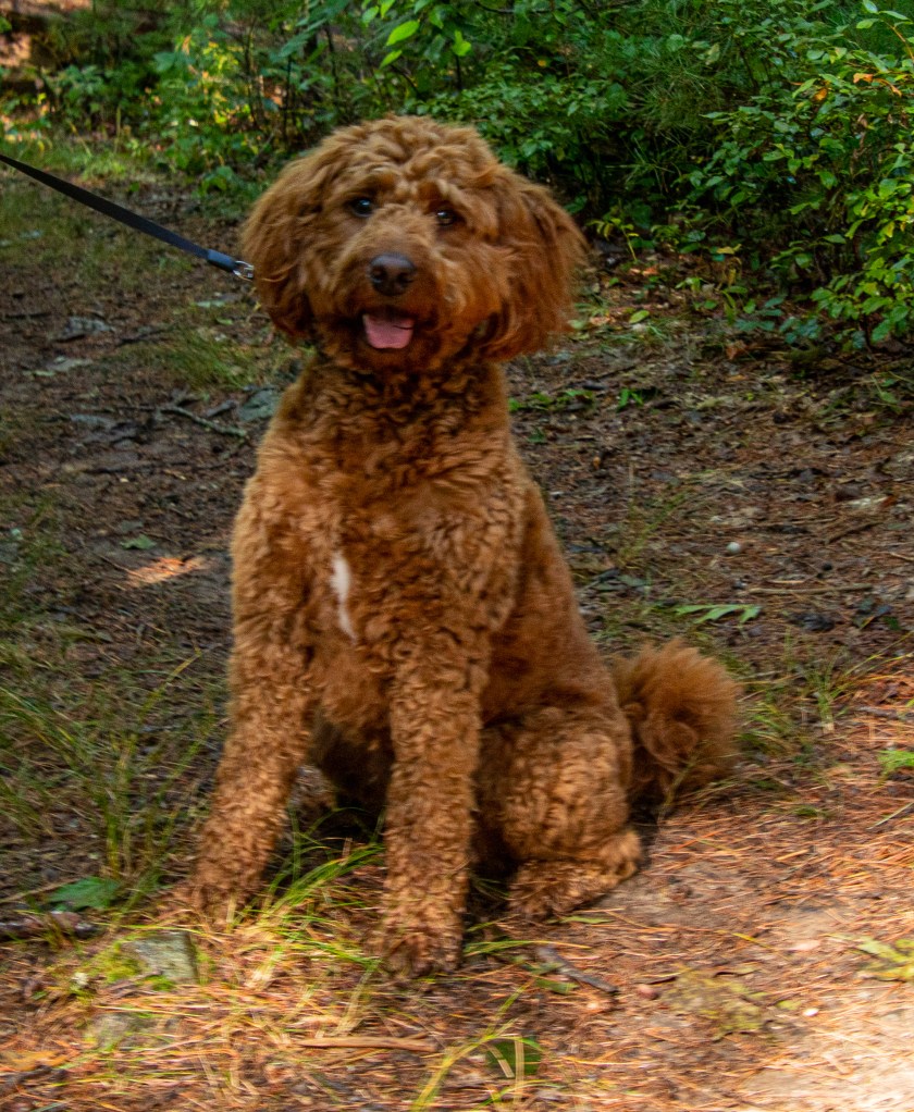
Norris Reservation is a dog friendly park.  Scout, a 2 year old Golden Doodle, was taking in the seasonably crisp pre-autumn weather with his dad.

IMG_7240

Since I don’t usually find light like this during my visits, even during the golden hour, I would mention some basic tips about lighting.  While, I am not expert and there are many videos on YouTube that offer advanced tips on this, I thought I would mention some things I noticed while I took my photos.

The first “duh” thing may be to make sure your not shooting directly at the sun and to hide behind a tree or other obstruction, so the light doesn’t give you any flare or sun spots.  Also, what you photograph isn’t what you saw when you were shooting, even if you do use the best settings.  I kept the ISO at 100 (and I wouldn’t recommend increasing it too much since you want to show the contrast between the ray of light and the darkness and shadows).  I also kept my aperture open (with an f stop between 3.5 and 4.5) and a slower shutter speed (between 1/15 and 1/60 sec).

You can always make adjustments in post production.  But, I only used minimal editing (such as cropping and adding very little exposure and contrast) because I want to “get it right in the camera” and show what I saw as I saw it.  This is particularly true with any photo that includes light, be it sunsets, sunrises or when the light is shining through the clouds or trees.

Attached is a very helpful video about how to shoot natural light in nature

The Nature Trail And Cranberry Bog (Foxboro, MA)

IMG_0867-2

Date Of Visit: May 18, 2019

Location: Patriot Place, behind Bass Pro Shops, 1 Bass Pro Dr, Foxborough, MA

Parking: there is parking available in front of Bass Pro Shop and additional parking usually reserved for visitors to the New England Patriot games across from the shop

Cost: Free

Hours: Open daily sunrise to sunset

Trail size/difficulty: .6 miles, easy

Universally Accessible: Yes

Dog Friendly: Yes

Highlights: scenic views, wildlife, easy trails

When one thinks of Patriot Place a cranberry bog and nature walk are probably not the first things that come to mind.  Yet, nestled right behind Bass Pro Shops at Patriot Place is a hidden trail with an array of wildlife and pretty views.

The trail, which can be easy to miss, is located right behind Bass Pro Shop at the end of the Patriot Place Plaza. But, before you begin the trail, there is a sitting area with a bench to rest on.

The .6 miles is an easy trail that has a pair of boardwalks and  dirt trails.

The boardwalk offers a great place to view birds and turtles.

But turtles aren’t the only aquatic critters at the trail.  I noticed a few snakes (Northern Water snakes) along the trail.  I thought it was funny this snake was on the side of the trail, yet nobody noticed as they walked along the trail.  While Northern Water Snakes are not venomous, they do have quite a nasty bite.  Fortunately, I do not speak from experience.  But I have read they can be dangerous if provoked.  They”re cute as a button though!

I also saw this animal there.  But, he or she didn’t move much, though.

IMG_0789

Leashed dogs are welcome to the trail.  Kobe, a 9 month old King Charles Cavalier, enjoyed the trail while I was visiting.

IMG_0757

Spring Bunny Quest (Francis William Bird Park, East Walpole, MA)

Date Of Event: April 27, 2019

Location: Francis William Bird Park, Polley Lane, Walpole, MA

Hours: Open daily from sunrise to sunset

Cost: Free

Parking: There are multiple parking lots located on Polley Lane, Pleasant Street and Rhoades Avenue.

Trail Size/Difficulty: 89 acres (3 miles of walking trails), easy

Handicapped Accessible: Yes

Dog Friendly: Yes

Highlights: wooden cutout bunnies hidden on the trails, trees, play areas, tennis and basketball courts, trees, ponds

Web Site: Francis William Bird Park

Trail Map: Francis William Bird Trail Map

Summary: 6 cutout bunnies were hidden along the various trails at Francis William Bird park

IMG_7658

While bunnies are not uncommon at William Francis Bird Park (more commonly known as “Bird Park”), there were a very different type of bunny there earlier this spring.  To mark the arrival of the spring cotton tail bunnies to the park, Bird Park hid 6 wooden cutout bunnies for visitors to look for.

While there was a map located at the visitor center board near the center of the park showing where the bunnies were located, the Trustees, who operate the park, encouraged visitors to find them on their own.  So, I tried.  I tried for 3 hours.  I was also taking photographs of the wide variety of beautiful trees and other treasures of the park.  I did find 5 of the bunnies on my own.  Then, I gave in and found the last bunny after looking at the map.

The bunnies really weren’t too hard to find.  Even the “hidden bunnies” were in open view, even if they were located next to a rock or tree.

The bunnies also had a small notepad for visitors to write messages.  One popular message written on the notepads can be seen below.

IMG_7593

The park has been a hidden attraction for many years.  In fact, it has existed in one form or another for almost 100 years.  Francis William Park was endowed and created by Charles Sumner Bird, Sr and his wife Anna in 1925.  The park was created in memory of their eldest son, Francis William Bird who died in 1918 at the age of 37.  The Trustees, who operate the park currently, gained ownership of the park in 2002.

Bird Park has so many great features,  The trails are easy to navigate and there are many toys and playthings for children to use in the “tot lot”.  There are also basketball courts and tennis courts.

The main attraction of the park, though, must be the trees.  There are a variety of trees at the park with the names of their particular species.

I wonder what species of tree this is.

IMG_7630

One particular tree at the park stands out among the rest.  A plaque dedicated to Charles Sumner Jr is located at the base of this majestic tree.

IMG_7624

IMG_7622-2

There are many stunning views at the park.

And, of course, what would Bird Park be without birds?

There are lots of benches to sit on and admire the views.  Some of these benches look pretty old!

In addition to an extensive play area, there is a cute little library in the children’s playground.

IMG_7743

The music court, built in 1931, was designed for performers to use to entertain the community.  There are changing rooms and restrooms (which I’m pretty sure are no longer in use) attached to the stage for performers to make costume changes before or during their performances.

Your dog will love the long trails and spacious field at the park.  The appropriately names Achilles, a 10 year old American Eskimo and Cocker Spaniel mix, didn’t let his injury stop him from roaming the park.

IMG_7688

Ruh roh!  It’s like Scooby, a 5 year old American Pitbull mix.  Zoinks!

IMG_7591

Bare Cove Park (Hingham, MA)

Date Of Visit: March 30, 2019

Location: Bare Cove Drive, Hingham, MA

Cost: Free

Hours: Daily, sunrise to sunset

Parking: There are 2 parking lots.  The larger parking lot located at Bare Cove Drive has room for about 100 cars.  There is also a smaller parking lot off Beal St

Trail Size/Difficulty: 484 acres, easy

Handicapped Accessible: Yes, there are paved trails but the side trails may not be accessible to all

Dog Friendly: Yes (see website for rules for taking dogs to the park)

Highlights: wildlife, birds, nature, lake, easy trails, cycling, running, scenic, museum

Website: Bare Cove Park

Map of Park: Bare Cove Park Map

IMG_5580

Once the site of a ammunition depot, Bare Cove Park is now a 484 acre park full of wildlife, scenic views and trails for running, cycling or just walking.

There is a variety of birds and other wildlife at the park.  Foxes, coyotes and even deer have been reportedly seen at the park.  So, do keep this in mind if you do bring your dog.  I didn’t see any aforementioned animals at the park.  But, I did see a diverse group of birds there.

Granted, I did have to go off the beaten paths to view some of these birds, particularly the hawks and kestrel.  But, you should see lots of cardinals, blue jays, sparrows and other smaller birds in your travels, even on the main trails.

The main trails are paved and wise in most parts.  So there is lots of room for cyclists, runners and people walking with their dogs.

IMG_5731

One of the many great things about Bare Cove is that it is beautiful all year.  You might think that it wouldn’t be very pretty during the early spring time.  You’d be wrong!  But, seriously, the natural colors and the trees are majestic.  Even the multi colored ones. Alt If you are looking to see plants and flowers and other colorful views I do recommend visiting in the mid to late spring, summer or, of course, fall.

One of the hidden historical aspects of the park is its military past.  The area was used to produce and distribute munitions and other military devices. Until 1971, military goods were produced here.

In an effort to commemorate the service of the people who worked at these depots, there is a small museum with exhibits, photos, military tools and other gadgets that were made at the depot.

IMG_5774

IMG_4931

There is also a viewing area to watch videos and DVDs about the history of the depot and how Weymouth and Hingham, MA contributed to the war effort.

There are two monuments outside of the museum.

One of the monuments is dedicated to all of the workers who helped the war efforts.

IMG_5772

The next memorial is dedicated to the workers who lost their lives when a ship they were unloading, the USS FY 415, exploded and sank on May 11, 1944, when signal rockets caught fire.

IMG_5839

Another interesting part of the area near the museum is that the posts which the bots tied onto when they originally unloaded their munitions at the depot are located in front of the museum.

There is also a fire museum nearby.  During my visit, a fire truck from the museum was on display at the park.

IMG_5508

But, the hidden history doesn’t end there.  A sign posted on Bare Cove Path indicates that an Almshouse (called “Town Farm”) used to be there.

IMG_5798

In short, almshouses were a place for the indigent or those who could not care for themselves.  To find out more about Almshouse, you can refer to my previous blog post about Almshouses.

With its winding trails and access to water, Bare Cove Park is a great place to take your dog.

IMG_5779

Kevin, a 2 year old Boston Terrier, posed for me during his walk around the park.

IMG_5871

Cooper, a 9 year old Golden Retriever, played fetch in the water during his visit.


Winter Island (Salem, MA)

IMG_4008

Date Of Visit: February 2, 2019

Location: 50 Winter Island Rd, Salem, MA

Hours: Open daily sunrise to sunset

Cost: Free

Parking: There is a parking area for about 20 to 30 cars at the park as well as street parking for about 2 dozen cars on Derby St before you arrive at Winter Island Rd

Handicapped Accessible: Yes.  However, some trails may be too steep

Dog Friendly: Yes

Size: 45 acres

Highlights: lighthouse, scenic views, military historical attraction, beach, easy trails, boat storage and launch areas, camping sites

Summary: Once the site of a fish drying and ship building location by the early settlers, Winter Island is now a haven for beach goers and boating enthusiasts.  Winter Island has easy trails with scenic views.  The most popular highlight of the park is Pickering Light which is located along the rocky shore.

IMG_3995-2

Ask anyone about Salem, MA, and you’re sure to hear about the House Of The Seven Gables, the Salem Witch Museum or one of the other historical museums, homes and shops that dot the city.  But, the best part of Salem may be miles (or more precisely a mile and a half) away from the historic downtown area.

Winter Island has a rich history as a shipbuilding area (a facility is still located there for this purpose) and as a defensive point for colonial and American forces during Queen Anne’s War and the American Revolutionary War.  It would continue to act in this capacity throughout the 19th century.  The area is also used to dry dock boats in the off season.  The area is used for people to camp in the RVs in the warmer seasons.  So the land is used year round.

IMG_4263

The lighthouse at Winter Island, Fort Pickering Light (aka Winter Island Light), was built to warn and protect sailors from the rocky coast.  Built in 1871, Pickering Light stands 28 feet above sea level,  It is built of iron lined with brick.  There used to be a bridge that connected the lighthouse to land.  I wish they had that there now!  Instead I had to walk down some rocks to get some photos up close.  The rocks can be slippery, especially this time of the year as it can be icy on the colder days.

There are also some military fortifications on display at the park.

From left to top left to bottom, Winter Island is a bunker installation and some markers in memory of those who were lost during war or other conflicts.

There is also a short trail that loops around park and offers some pretty views of the harbor.  Like most places, the best times to visit are during sunrise or sunset (or just before each time of day).  But, it is especially true here.  The orange, gold and blues help to accentuate the beauty of the park.  I spent quite a while at the park to ensure I could capture a few shots just before sunrise.  You gotta love those “golden hours.”

Don’t let the warm colors of the sunset fool you.  What looks like chunks of ice in these photos is actually ice on top of the lobster traps in the water.

IMG_4114

There are lots of ducks, seagulls and other birds at Winter Island.

There also seems to be a lot of reconstruction at the park.  This building looked like it was being gutted and perhaps renovated for future use.

A hidden gen within this hidden gem is Waikiki Beach.  The first sign you’ll see after you arrive at the entrance to the park is probably going to be the sign to Waikiki Beach.  While it may not compare to the beach in Hawaii that shares its name, it is a second close.

In the colder seasons you may find people skating or practicing hockey on the pond.

IMG_4055

The beach is usually packed with sun seekers and beach lovers during the warmer months, it is also a popular place for people to go and play with your dogs during the winter months.

IMG_4012

Rigby is a 5 year old mixed breed dog. His mom told me he had fun playing with Oliver at Waikiki Beach.  I have photographed Oliver in the past.  As his Instagram profile states he is a “good boy.”  You can find him here on Instagram or at oliverbestdog.

IMG_4031

Similar places I have visited:
(Hidden) Things to do in the area:


Fort Revere (Hull, MA)

Date Of Visit: January 12, 2019

Location: Fort Revere, Telegraph Hill, 60 Farina Rd, Hull, MA

Hours: Open daily from dawn until dusk

Cost: Free

Parking: There is room for about 10-15 cars in the parking lot

Handicapped Accessible: The fort is not handicapped accessible but there are views that can be enjoyed from the hill at the parking lot

Dog Friendly: Yes

Highlights: scenic, historical, picnic areas, barbecue grills

Summary: The former site of American fortification during the American Revolution, Fort Revere has also scenic views and picnic areas.

Websites: Fort Revere

Mass.gov Fort Revere Website

img_2994-2

As most people about Hull, Mass, and they will undoubtedly reference Nantasket Beach, the old Paragon Park and maybe even the Red Parrot.

But, the most beautiful part of Hull may be hidden up an otherwise unremarkable side road. In fact, you may easily drive by Farina Rd if you are not already aware of the beauty that sits atop the road.

For Revere offers some of the most beautiful views this side of Boston.

The views of Boston Harbor from Fort Revere are nothing less than breath taking. Boston Light is visible in the foreground and Graves Light stands behind it in the distance.

Once used as a American military installation during the American Revolution and later used as the site of a storehouse, Fort Revere is a truly hidden historical treasure. Although it is a shame it is used more for graffiti and other unproductive activities.

The steps at the fort are in disrepair. So be careful if you do visit.

On July 14, 1976 (Bastille Day) Fort Revere dedicated a memorial that commemorates the French forces who served and died at the fort in the American Revolution.

The memorials are written in English and French.

The graves from some of the people who served there still remain below the fort. You may notice rocks left on some of the tombstones.

img_2947

The bridge on to Spinnaker Hill Lane leads to Hog Island and there are pretty views of the coast of Hull.

There is also a tower that is no longer in use at Fort Revere.

img_2985-2

Fort Revere is a dog friendly attraction. These two Cocopoos (a Cocker Spaniel and Poodle mixed breed) named Sajac, the brown 10 year old dog in front, and Deacon, the white 1 year old dog in back, enjoyed walking around the fort.

img_2976-3

Bear Hole Reservoir Trail (West Springfield, MA)

Dates Of Visits: December 26 & 27, 2018

Locations: Bear Hole Rd, West Springfield, MA and 175 Bridle Path Rd, West Springfield, MA

Hours: Open daily, dawn until dusk

Cost: Free

Parking: There is a parking area at the end of Bear Hole Rd for about 20 cars

Trail Size/Difficulty: 1,700 acres, 2.6 mile gravel and dirt loop, easy with a few average inclines

Handicapped Accessible: No, some of the trails are rocky, unpaved and steep

Dog Friendly: Yes

Highlights: vernal pools, waterfall, running, hiking, cycling, dog friendly (leashed), waterfall, wildlife, scenic views

Map: Bear Hole Reservation Trail Map (myhikes.com)

Websites: Bear Hole Reservoir Trail (alltrails.com)

Bear Hole Reservior Trail (myhikes.com)

Nestled at the end of what may seem like any other side street off Dewey St in West Springfield, MA, Bear Hole Reservoir Trail is truly a hidden gem.  If not for a relative who clued me into this hidden treasure, I may not have known it existed.  In fact, the first time I drove to the reservoir, I wasn’t quite sure I was going the correct way.  I’m sure many people drive by the main road that leads to the reservoir without realizing it.

Once thought to be the home of the Woronocos, a sub-group of the
Pocumtucks, Bear Hole Reservoir Trail has many natural wonders.Bear Hole Reservoir, which was built in 1956, was meant to deliver drinking water to the residents of West Springfield.  However, according to a 2012 report states the Bear Hole Reservoir and Treatment Facility has been inactive since 2011 although the West Springfield Works Department do still monitor the water supply.  Reports of seepage, poor construction and spalling concrete are a few of the reasons the reservoir is not in use for the town’s water supply.  However, it seems like it could be used as a water supply if there were drought like conditions or the main source of water was compromised.

The first attraction at you will probably see at Bear Hole is the waterfall and stream that leads to the head of the reservoir.

A variety of wildlife, such as deer, bears and even the occasional beaver have been reported and photographed at Bear Hole.

IMG_1921

I found this beaver chewing on a piece of vegetation when I went off the main trail.  There is a worn trail off the main trail by the waterfall, which is part of the Paucatuck Brook, where you can walk closer to the stream of water.  Although I didn’t see any deer, I did find evidence of them.

The head of the reservoir, which was partially frozen due to the cold temperatures, and the views along the way are a sight worth seeing.  The short hike is definitely worth it.

The tree-lined dirt trail is easy.  The only steep part is the incline from the front part of the reservoir onto the second part of the loop.  It may be better for some people to backtrack from the way you came as this trail is easier.  But, it will be longer than taking the loop back.

There are lots of pretty views along the trails, especially this time of the year with the icy vernal ponds.  I suppose that’s kind of ironic to type that.  But, I have gained a deeper appreciation over time for the skeletal tree structures and the icy bodies of water.  Bear Hole is proof that beauty does not only exist during the warmer seasons.

Leashed pets, and maybe some well behaved dogs off leash, are allowed at Bear Hole.  One of the dogs I saw on the trail is Roxie, a 3 year old Basenji (Africa’s “barkless dog”).

IMG_0283

I look forward to bringing more of Hidden New England to you.  If you would like to learn more about the hidden gems of New England, please take a moment to check out my Facebook page at https://www.facebook.com/hiddennewengland/ and like or follow me there.  I plan on posting links and other information on my Facebook page that may not be included in my blog posts.