Hidden History – Moswetuset Hummock (Quincy, MA)

Date Of Visit: March 39, 2019

Location: Moswetuset Hummock, 440 East Squantum St, Quincy, MA

Hours: open daily, dawn to dusk

Cost: Free

Parking: Free parking is available for about a dozen vehicles:

Universally Accessible: Because of the dirt and rocky surface and a few slight inclines it is not universally accessible

Dog Friendly: Yes

Highlights: views of Quincy and the surrounding area, short trail, historic importance

Summary: A small, often overlooked park in Quincy, MA, has a special historical significance to Massachusetts

IMG_5884

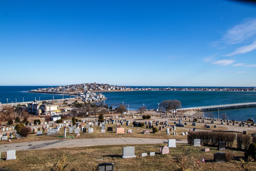
Sometimes hidden history is in the wide open.  Such is the case with the small park located along the Wollaston Beach and Quincy Bay area.

The .4 mile loop (yes it is a very short trail) is easy.  Along the short trail you’ll see pretty views of the neighboring Wollaston Beach and Squantum (another name with a historical connection to the area).

While the trail at Moswetuset is short and easy, if you walk down the somewhat steep side of the trail, you can get some pretty views of Boston and the Quincy area.  These photos were taken from the rocky area off the main trail during twilight in March.

Moswetuset, which means “shaped like an arrowhead”, is often overlooked for the more popular Wollaston Beach which is located around the corner from Moswetuset.  Yet, the fact that it is overlooked gives it a special charm.   It also has an interesting historical background.

Moswetuset is said to have been the seat of the ruling Massachusetts Chief Chickatawbut.  It is also the place where Plymouth colony commander Myles Standish and his guide Tisquantum (Squanto) met with Chief Chicktawbut in 1621.

Named after the native tribe of Moswetuset, the name of this area would later become known as Massachusetts.

IMG_5888

As the sign below states, Chief Chickawawbut agreed to a treaty with then Governor Winthrop which neither side broke.  And, of course, there is a Dunkin’ Donuts across the street which you may see in the background.  It is Massachusetts after all.

IMG_5958

From Wollaston Beach the area looks simply like a wooded area without much to see.

Yet, hidden within that cluster of trees lies a true hidden treasure with a hidden history.


Bare Cove Park (Hingham, MA)

Date Of Visit: March 30, 2019

Location: Bare Cove Drive, Hingham, MA

Cost: Free

Hours: Daily, sunrise to sunset

Parking: There are 2 parking lots.  The larger parking lot located at Bare Cove Drive has room for about 100 cars.  There is also a smaller parking lot off Beal St

Trail Size/Difficulty: 484 acres, easy

Handicapped Accessible: Yes, there are paved trails but the side trails may not be accessible to all

Dog Friendly: Yes (see website for rules for taking dogs to the park)

Highlights: wildlife, birds, nature, lake, easy trails, cycling, running, scenic, museum

Website: Bare Cove Park

Map of Park: Bare Cove Park Map

IMG_5580

Once the site of a ammunition depot, Bare Cove Park is now a 484 acre park full of wildlife, scenic views and trails for running, cycling or just walking.

There is a variety of birds and other wildlife at the park.  Foxes, coyotes and even deer have been reportedly seen at the park.  So, do keep this in mind if you do bring your dog.  I didn’t see any aforementioned animals at the park.  But, I did see a diverse group of birds there.

Granted, I did have to go off the beaten paths to view some of these birds, particularly the hawks and kestrel.  But, you should see lots of cardinals, blue jays, sparrows and other smaller birds in your travels, even on the main trails.

The main trails are paved and wise in most parts.  So there is lots of room for cyclists, runners and people walking with their dogs.

IMG_5731

One of the many great things about Bare Cove is that it is beautiful all year.  You might think that it wouldn’t be very pretty during the early spring time.  You’d be wrong!  But, seriously, the natural colors and the trees are majestic.  Even the multi colored ones. Alt If you are looking to see plants and flowers and other colorful views I do recommend visiting in the mid to late spring, summer or, of course, fall.

One of the hidden historical aspects of the park is its military past.  The area was used to produce and distribute munitions and other military devices. Until 1971, military goods were produced here.

In an effort to commemorate the service of the people who worked at these depots, there is a small museum with exhibits, photos, military tools and other gadgets that were made at the depot.

IMG_5774

IMG_4931

There is also a viewing area to watch videos and DVDs about the history of the depot and how Weymouth and Hingham, MA contributed to the war effort.

There are two monuments outside of the museum.

One of the monuments is dedicated to all of the workers who helped the war efforts.

IMG_5772

The next memorial is dedicated to the workers who lost their lives when a ship they were unloading, the USS FY 415, exploded and sank on May 11, 1944, when signal rockets caught fire.

IMG_5839

Another interesting part of the area near the museum is that the posts which the bots tied onto when they originally unloaded their munitions at the depot are located in front of the museum.

There is also a fire museum nearby.  During my visit, a fire truck from the museum was on display at the park.

IMG_5508

But, the hidden history doesn’t end there.  A sign posted on Bare Cove Path indicates that an Almshouse (called “Town Farm”) used to be there.

IMG_5798

In short, almshouses were a place for the indigent or those who could not care for themselves.  To find out more about Almshouse, you can refer to my previous blog post about Almshouses.

With its winding trails and access to water, Bare Cove Park is a great place to take your dog.

IMG_5779

Kevin, a 2 year old Boston Terrier, posed for me during his walk around the park.

IMG_5871

Cooper, a 9 year old Golden Retriever, played fetch in the water during his visit.


Hidden History – Almshouse (Hingham, MA)

Date Of Visit: March 30, 2019

Location: Bare Cove Park, 45 Bare Cove Dr, Hingham, MA

Summary: Bare Cove Park was once home to one of the first charitable groups in the colonies and states.  “Town Farm” at Bare Cove was one of the many almshouses in the states.

IMG_5798

New England has a long history of helping others.  One of the ways the people of New England have reached out to help others is with the creation of Almshouses..  In Christian tradition, alms are money or services donated to support the poor and indigent.

In short, Almshouses were charitable housing units designed to help the indigent, particularly widows, the elderly and those unable to pay their rent.  They were maintained by a community or charitable group.  Originally, they were attached to churches and other religious groups.  They were later adopted by local officials and governing bodies.

Although they have a short history in the colonies and states, they have a much longer history in Europe.  In fact, Almshouses are a tradition that was brought over from England.  The first recorded almshouse is said to have been built in 1132 at the Hospital of Saint Cross in Winchester, England. It is still in existence today.

The almshouse in Hingham, MA, (“Town Farm”) which once stood in the area in the photograph below was built  in 1832 and it lasted just over 100 years. It was the third almshouse in the city.  Although the sign doesn’t say specifically where the almshouse was, it was in this general area.  Trees, a few condos just out of view behind the trees and access roads now stand where the almshouse once stood.  This sign, where the defunct almshouse once stood, is located on Bare Cove Path at Bare Cove Park.

IMG_5800

Almshouses in the colonies and states were not just a product of Hingham, MA, though.  In fact, almshouses were abundant throughout the colonies and United States way before Hingham erected “Town Farm.”

The first almshouse in the United States was founded in Boston, Massachusetts in 1622. The original Almshouse was burned down in 1682. When they decided to rebuild it they chose a different location.  But, these alhouses also dotted the Northeast in such places as Pennsylvania.

However, almshouses weren’t just used for altruistic purposes.  In addition to providing a needed home for the poor, mentally ill and physically impaired, the homes were also used by some as a place to drop off vagrants, criminals and addicts.  This made some of the almshouses unsafe.  Allegations of neglect and unsanitary conditions were also rampant at some of the homes.

By the late 1800s and part of the 1900s, almshouses were largely gone.  This was in part because the Social Security Act prohibited federally aided old-age assistance to residents of public institutions.  This was because the creation Social Security was thought to make these types of homes unnecessary.  Little did they realize how healthcare costs would sky rocket in the ensuing years.  The prohibition of legally funded almshouses also paved the way for privatized elderly care homes.


Hidden History – Naumkeag (Salem, MA)

Date Of Visit: February 2, 2019

Location: Salem, MA (formerly Naumkeag)

Summary: The area now known as Salem, MA, was once known for so much more than the venue of the witch hysteria.

Although much is made of the Salem witch trials, there is much more to Salem’s history than this dark spot on the city’s past.

Long before Roger Conant settled in what is now Salem, MA, in the 1620s, the Naumkeag tribe had settled in what is now considered Essex County, comprising essentially the northeast corner of MA.  Although the area originally kept the name Naumkeag, the settlers would decide to change the name.  Naumkeag would eventually become known by its current name of Salem, a name derived from the Hebrew word for peace.

What is interesting is Salem is not the only area which bears the name Naumkeag.  Some areas of western Massachusetts, specifically an estate in Stockbridge bears this name.  If it is named after the same tribe that would be quite a distance to travel (well over 100 miles).  It’s not clear if the same tribe once lived there.  But, it’s more likely the name was derived from the Algonkian name for “fish” which I will touch on later in this post.

Salem keeps ties to the Naumkeag name with some businesses bearing the name and this building on Essex St that some people may never have noticed also bears the name of the area.  Most prominently, the building houses the liquor store Pamplemousse (185 Essex St) in addition to other shops.

IMG_3639

The name is not listed prominently.  So it could be easy to miss.  But, if you look up you can’t miss it.

IMG_3636

The name Naumkeag is most likely derived from the Algonkian root “Namas” meaning “fish.”  As the waterways of Salem were once plentiful with fish and fish was such a major food source this is a logical conclusion. In fact, after a quick search of restaurants in Salem it is evident it still relies on fish and other seafood for its economy.

The native Naumkeag was settled some 4,000 years ago as a seasonal fishing settlement.  Eventually, it became part of  a colonial settlement, as was the case with many former Native American settlements.  Roger Conant would settle that area and a much larger area in 1629.  Now, it is a mere footprint on a city which is rich in many aspects of American history.  In fact, it is plausible to write more hidden histories on Salem as it has played an essential role in many historical events other than the witch trials.  And it all started in a place called Naumkeag.

So, the next time you’re shopping on Essex St or photographing the Halloween revelers, take a look up and note that you’re actually at Naumkeag Block.


To receive updates when I post on this page and view other content I do not post on this page please consider liking my Facebook page at the following link: Hidden New England

Winter Island (Salem, MA)

IMG_4008

Date Of Visit: February 2, 2019

Location: 50 Winter Island Rd, Salem, MA

Hours: Open daily sunrise to sunset

Cost: Free

Parking: There is a parking area for about 20 to 30 cars at the park as well as street parking for about 2 dozen cars on Derby St before you arrive at Winter Island Rd

Handicapped Accessible: Yes.  However, some trails may be too steep

Dog Friendly: Yes

Size: 45 acres

Highlights: lighthouse, scenic views, military historical attraction, beach, easy trails, boat storage and launch areas, camping sites

Summary: Once the site of a fish drying and ship building location by the early settlers, Winter Island is now a haven for beach goers and boating enthusiasts.  Winter Island has easy trails with scenic views.  The most popular highlight of the park is Pickering Light which is located along the rocky shore.

IMG_3995-2

Ask anyone about Salem, MA, and you’re sure to hear about the House Of The Seven Gables, the Salem Witch Museum or one of the other historical museums, homes and shops that dot the city.  But, the best part of Salem may be miles (or more precisely a mile and a half) away from the historic downtown area.

Winter Island has a rich history as a shipbuilding area (a facility is still located there for this purpose) and as a defensive point for colonial and American forces during Queen Anne’s War and the American Revolutionary War.  It would continue to act in this capacity throughout the 19th century.  The area is also used to dry dock boats in the off season.  The area is used for people to camp in the RVs in the warmer seasons.  So the land is used year round.

IMG_4263

The lighthouse at Winter Island, Fort Pickering Light (aka Winter Island Light), was built to warn and protect sailors from the rocky coast.  Built in 1871, Pickering Light stands 28 feet above sea level,  It is built of iron lined with brick.  There used to be a bridge that connected the lighthouse to land.  I wish they had that there now!  Instead I had to walk down some rocks to get some photos up close.  The rocks can be slippery, especially this time of the year as it can be icy on the colder days.

There are also some military fortifications on display at the park.

From left to top left to bottom, Winter Island is a bunker installation and some markers in memory of those who were lost during war or other conflicts.

There is also a short trail that loops around park and offers some pretty views of the harbor.  Like most places, the best times to visit are during sunrise or sunset (or just before each time of day).  But, it is especially true here.  The orange, gold and blues help to accentuate the beauty of the park.  I spent quite a while at the park to ensure I could capture a few shots just before sunrise.  You gotta love those “golden hours.”

Don’t let the warm colors of the sunset fool you.  What looks like chunks of ice in these photos is actually ice on top of the lobster traps in the water.

IMG_4114

There are lots of ducks, seagulls and other birds at Winter Island.

There also seems to be a lot of reconstruction at the park.  This building looked like it was being gutted and perhaps renovated for future use.

A hidden gen within this hidden gem is Waikiki Beach.  The first sign you’ll see after you arrive at the entrance to the park is probably going to be the sign to Waikiki Beach.  While it may not compare to the beach in Hawaii that shares its name, it is a second close.

In the colder seasons you may find people skating or practicing hockey on the pond.

IMG_4055

The beach is usually packed with sun seekers and beach lovers during the warmer months, it is also a popular place for people to go and play with your dogs during the winter months.

IMG_4012

Rigby is a 5 year old mixed breed dog. His mom told me he had fun playing with Oliver at Waikiki Beach.  I have photographed Oliver in the past.  As his Instagram profile states he is a “good boy.”  You can find him here on Instagram or at oliverbestdog.

IMG_4031

Similar places I have visited:
(Hidden) Things to do in the area:


Hidden History – Whip City (Westfield, MA)

img_3214-2

Date Of Visits: January 25, 2019

Locations: Westfield, MA

Summary: The first and once leading manufacturer of whips in the United States, Westfield, MA, still retains the title of “whip city.”

As a new feature to my blog I am featuring a monthly historical account of one New England city, town or area.  But, my goal is to not focus on the obvious or well known historical aspects of certain areas.  Nor do I necessarily want to focus on the historically famous cities and towns in New England.  Rather, I am going to bring lesser known historical accounts of certain areas in New England.  Every area in New England has a hidden history and I hope these posts help to bring some light to these hidden pasts.

Whip City Music, Whip City Brew, Whip City Candle Company.  Why do so many places and shops in Westfield, MA have “whip city” in their name?

The short is because it is “whip city.”

Back in the horse and buggy days of the early 1900s (shortly before my birth), Westfield, MA, was the leading center of the buggy whip industry.  However, as automobiles became more affordable and accessible, the whip industry declined and many of the whip businesses closed shop.  Interestingly, the first car that was built in the United States (it was really a horse drawn buggy with a 4 HP, single cylinder gasoline engine) made its first run on public roads on September 21, 1893 in neighboring Springfield, MA.

The “whip city” brand still lives on.  Dozens of businesses from a siding and window installing company to a travel agency share the “whip city” name.  And the whip industry isn’t exactly dead.  Not yet at least.

People can still have whips made for whatever your purpose at Westfield Whip. The last remaining whip company in Westfield, MA, Westfield Whip was established in 1884.  Located at 360 Elm St, it is very easy to drive by the building and not notice its historical importance.  It may seem like any other old building in a city of old buildings.  But, it has a long history of industry and commerce in the city.  In fact it is such an important piece of history that it was placed on the National List of Historic Places on October 17, 1985.  The Westfield River runs along the side of the whip manufacturing building.  It was shuttered when I went to visit it Friday and it is only open by appointment only.

In 1872, Henry Martin Van Duesen formed his first partnership in Southfield and moved his business to Westfield in 1880 making it the first whip manufacturer in what would later be designated “whip city.”  Van Duesen began his career in the whip industry as a whip braider at the age of 11.  The building which once stood as the first whip building manufacturer was changed by Duesen to a factory to the production of lawn swings in 1925.  Stanley Hardware bought the factory in 1936 .  Now, it functions as an apartment building located at 42 Arnold St.  But it still retained the name of Van Duesen.

I did gain access to the front desk area and the friendly office worker allowed me to take a photo of the inside of the office area.  Just looking at the brick interior and the structure of the room you can see how it once certainly could have been used to manufacture goods.

img_3173

Fort Revere (Hull, MA)

Date Of Visit: January 12, 2019

Location: Fort Revere, Telegraph Hill, 60 Farina Rd, Hull, MA

Hours: Open daily from dawn until dusk

Cost: Free

Parking: There is room for about 10-15 cars in the parking lot

Handicapped Accessible: The fort is not handicapped accessible but there are views that can be enjoyed from the hill at the parking lot

Dog Friendly: Yes

Highlights: scenic, historical, picnic areas, barbecue grills

Summary: The former site of American fortification during the American Revolution, Fort Revere has also scenic views and picnic areas.

Websites: Fort Revere

Mass.gov Fort Revere Website

img_2994-2

As most people about Hull, Mass, and they will undoubtedly reference Nantasket Beach, the old Paragon Park and maybe even the Red Parrot.

But, the most beautiful part of Hull may be hidden up an otherwise unremarkable side road. In fact, you may easily drive by Farina Rd if you are not already aware of the beauty that sits atop the road.

For Revere offers some of the most beautiful views this side of Boston.

The views of Boston Harbor from Fort Revere are nothing less than breath taking. Boston Light is visible in the foreground and Graves Light stands behind it in the distance.

Once used as a American military installation during the American Revolution and later used as the site of a storehouse, Fort Revere is a truly hidden historical treasure. Although it is a shame it is used more for graffiti and other unproductive activities.

The steps at the fort are in disrepair. So be careful if you do visit.

On July 14, 1976 (Bastille Day) Fort Revere dedicated a memorial that commemorates the French forces who served and died at the fort in the American Revolution.

The memorials are written in English and French.

The graves from some of the people who served there still remain below the fort. You may notice rocks left on some of the tombstones.

img_2947

The bridge on to Spinnaker Hill Lane leads to Hog Island and there are pretty views of the coast of Hull.

There is also a tower that is no longer in use at Fort Revere.

img_2985-2

Fort Revere is a dog friendly attraction. These two Cocopoos (a Cocker Spaniel and Poodle mixed breed) named Sajac, the brown 10 year old dog in front, and Deacon, the white 1 year old dog in back, enjoyed walking around the fort.

img_2976-3